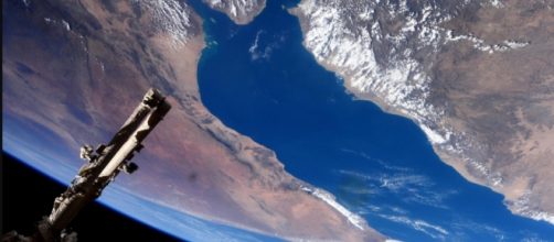
Street View in Google has revealed an interactive experience for earthlings who can now explore the international space station. Google went off-planet for the first time courtesy of Thomas Pesquet who is an astronaut at the European Space Agency. The flight engineer was reported by Newsweek to have spent six months capturing Street View Imagery.
Street View of the ISS captured by flight engineer
In the Blog Welcome to Outer Space, Pesquet wrote that it was not easy to actually explain in words or even through images just how it feels to be space.
Nevertheless, working with Google, he was able to capture street views of the International Space Station that now enable those of us stuck on Planet Earth to explore the views of our own planet from space, and to get around the actual Space Station itself.
Google Street View has proven to be a useful resource across the world for students and travelers and is endlessly interesting to ordinary people and those who entertain by finding raunchy images in odd places. Google Street View is even more fascinating now that they have literally gone way beyond the streets of the world. There is a surge of renewed interest in maps this week as people are flocking to Google Maps, so it can be safely assumed that The International Space Station just had more "visitors" than in the history of the project.
Google Voyager will whet your appetite
To find out more about the International Space Station in Street View, you can navigate to the Google Voyager Website where it sits alongside "The Adventure Behind Chasing Coral," and "Futuristic Architecture." Google's intro is sure to pique interest as they describe the International Space Station experience as, "Discover the ISS in Street View, captured in partnership with NASA, ESA, JAXA, Roscosmos, and CASIS."
To whet your appetite you can visit the Photo Sphere to explore the inside of the International Space Station. The Cupola Observational Module is one of the most intriguing places to visit. Designed as a platform where robotic activities, the approach of vehicles and extravehicular activity (EVA) can be observed, it is possible for us to see the earth from space, but the real interactive experience is found in Google Maps itself.
Google Maps - the Space Station navigation
If you prefer to view through Google Maps direct it is easy enough to navigate directly to Googe Maps where you will discover that as described by TechCrunch, it’s all about clicking through the imagery yourself. Navigation is simple, with symbols, ports, and notes, but don't be surprised if you end up getting a bit lost. This is space after all and sometimes the exit is below you, or above your head. The impression of floating is very strong as you explore your way to the Internation Space Station, so head on over and check it out.
With Google Street View you can now explore the International Space Station https://t.co/ZnfcvbsNmA pic.twitter.com/X6phuHfRLR
— Guide Me Tech (@guide_metech) July 21, 2017

