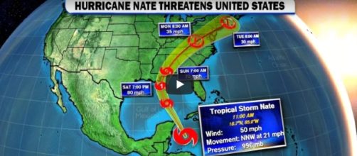
Hurricane Nate will bring high winds and rain to the Gulf Coast. The National Hurricane Center (NHC) confirmed that "an Air Force Reserve Hurricane Hunter aircraft penetrated the center of Nate and reported hurricane-force winds. The maximum winds are estimated to be 75 mph (120 km/h) with higher gusts expected."
Hurricane Nate is south of Mississippi River
The announcement was made on the nhc.noaa site at 1030 PM CDT by the NHC in Miami Florida. At the time of the announcement, the hurricane was lying about 95 miles west north-west of Cuba and tracking north north-west.
It was about 495 miles south of the mouth of the Mississippi River.
Scary. Hope and pray this is not another tragedy. #Hurrican Nate pic.twitter.com/BbP0neMF10
— Jane Flowers (@zimkwacha) October 7, 2017
In an earlier NOAA notice, it was reported that Nate was "likely to become a hurricane overnight." Hurrican Nate storm warnings have already emerged, with storm surges and flooding predicted for the northern Gulf Coast. Residents from Morgan City, Louisiana, to the Okaloosa/Walton county line in Florida, have been urged to comply with any evacuation orders that may be issued.
Nate will bring heavy rain to lower Ohio Valley
It is anticipated that Hurricane Nate will arrive with heavy rainfall from the east of the Mississippi River and around the central Gulf Coast, reaching the Deep South, eastern Tennessee Valley, and the southern Appalachians through Monday.
Flashfloods could occur in the region. Sunday and Monday could see 6 inches of rain falling in the lower Ohio Valley and into the central Appalachians.
CNN reported that Hurricane Nate is likely to hit the New Orleans area which was devastated by Hurricane Katrina in 2012. Nate has already killed 24 people as it tracked across Costa Rica, Nicaragua and Honduras.
Governor Landrieu orders mandatory evacuations in New Orleans areas
Mayor Mitch Landrieu of New Orleans already declared a state of emergency and "ordered a mandatory evacuation of the Venetian Isles, Lake Catherine, and Irish Bayou areas of the city," CNN confirmed. Governor John Bel Edwards warned people who live "outside the city's levee protection system or in low-lying areas," to move to higher ground.
Landfall point of hurricane Nate hard to pinpoint at this time
weather.com has reported that "Heavy rain continues to fall across parts of western Cuba and Mexico's Yucatan Peninsula. Rain showers are occasionally passing through offshore Florida waters and the Florida Keys." They also pointed out that the area the hurricane is headed for has complex "geography," so pinpointing an exact landfall is difficult to predict at this time. Nevertheless, "the overall track will bring Nate through the northern Gulf Coast and into the Southeast this weekend."
Hurricane Nate will the third storm to slam into the USA in just six weeks.

