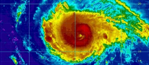
Hurricane Irma has moved into the Caribbean, putting Puerto Rico, the Bahamas, the Dominican Republic, the Virgin Islands, Haiti, and Cuba in great danger. The storm is a Category 5 and is one of the strongest Atlantic storms ever recorded, and it continues to move along. Satellite images show the storm moving north-west as it has already passed over the French Caribbean islands of Saint Martin and Saint Barthelemy.
The storm is so powerful that even meteorologists and experts are baffled by the sheer size of the storm. Hurricane scientist Taylor Trogdon posted a tweet that has gone viral with an image of the storm moving across the Caribbean, saying he is at an "utter loss for words" as he tries to describe the devastating storm.
I am at a complete and utter loss for words looking at Irma's appearance on satellite imagery. pic.twitter.com/B0ewFyvcSv
— Taylor Trogdon (@TTrogdon) September 5, 2017
Government assistance is already underway in areas of Florida and United States islands in the Caribbean as President Trump has declared a state of emergency in those areas. Local governors and prime ministers are working around the clock in affected areas to control the evacuations and any necessary care for those in need.
French Caribbean
French islands in the Caribbean have already suffered catastrophic damage. The streets are flooded, cars, boats, and trees have been thrown around, and buildings have been damaged. The reported wind gusts from the storm in the east Caribbean have been recorded as high as 185 Miles Per Hour, according to Fox News.
The French government is already taking action to send assistance to their territory islands.
RCI Guadeloupe's Twitter account has been posting tweets of the storm from Saint Martin showing the destruction and flooding that Irma has caused in the area. What is seen in the background is a harbor of boats that have been piled on top of each other from the strong winds and waves, as well as the flooded streets.
[IRMA] Saint Martin dans le mur de l'oeil subit les effets de l'ouragan IRMA #iram #ouragan #SaintMartin (Source : Rinsy Xieng) pic.twitter.com/e2j7e9KtOu
— RCI Guadeloupe (@RCI_GP) September 6, 2017
On the move
Irma is moving northwest at about 16 miles per hour as the Bahamas, the Dominican Republic and Puerto Rico stand it its way.
The projected winds when it reaches landfall are said to be 180+ miles per hour. Prime Minister Hubert Minnis ordered a complete evacuation of the following Bahama islands: Mayaguana, Inagua, Crooked Island, Acklins, Long Cay, and Ragged Island. This will be the biggest evacuation in the Bahamas and these people will be relocated to Nassau and New Providence.
Tomorrow and Friday are the days that Irma is expected to hit the Bahamas and the north end of the Dominican Republic, with Puerto Rico being hit today. The National Weather Service map shows that Puerto Rico will be completely under the path of the storm today, which has a population of 3.4 million. It was reported that around 700 people in the northeast region of Puerto Rico are taking cover in shelters, as said by Governor Ricardo Rossello in a press conference.
The storm will make its way to the south Florida coast sometime Sunday morning around 8 AM. The Florida National Guard is on high alert, with a state of emergency declared for the entire state by Governor Rick Scott. They are prepared for evacuation in the Florida coastal areas, and all 7,000 National Guard members will be reporting tomorrow morning to provide help along the way. In addition to the evacuation of some areas, other places will attempt to provide shelter, including public school buildings and other designated areas.
This morning I was briefed by @monroecounty E.M. & local leaders about their efforts to prepare for #HurricaneIrma & keep families safe. pic.twitter.com/9X3flyL9fA
— Rick Scott (@FLGovScott) September 6, 2017


