Everyone can envision the primary danger posed by a hurricane - the high winds. We’ve all been in wind storms and know that even a 50 mph wind can bring down trees, especially if there has been a lot of rain softening the ground around the roots. But hurricane winds and the tornados they sometimes trigger are often short term events with the hurricane hitting land and quickly dying.
Not so with Harvey. Also, high winds aren't the only damage caused by major storms. Sometimes there is damaging Storm Surge and catastrophic rain events.
Storm Surge
Just what is a storm surge?
We hear about it with every tropical storm, but most people don’t really understand it. The often dangerous event is caused by two factors.
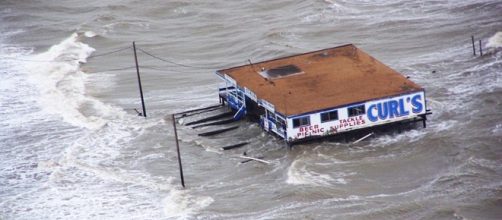
First, as a hurricane approaches the coast, it has a lower air pressure, lowest at the center or eye. At sea, the effect of this lowered pressure isn’t noticeable, but as it approaches land, the lower pressure actually raises sea level a foot or two - depending on how low the pressure is.
The second factor is dependent on the storm’s wind speed, the sea level, and the shape of the coast. This factor is simply the effect of strong winds blowing over hundreds of miles, further raising the sea level. This piling up can raise the water level by inches or a dozen feet.
The Coriolis effect, which is related to the earth’s rotation, causes hurricanes to rotate in the counter-clockwise direction in the Northern Hemisphere (Also tornados and even the water in your bathtub going down the drain.) So the wind on the eastern side of a hurricane will blow toward the north on the eastern side. If this is near land on the northern side of the storm, then the storm surge will pile up water on that side and actually lower water on the side where the wind blows away from land.
In this case, Harvey will pile up the storm surge to the east of where it strikes land and that wind effect will combine with the low pressure (which is still decreasing as of 8 pm Friday) to cause a storm surge of about 12 feet above normal sea level (dependant on the tide).
If the wind is also blowing into a harbor or land masses which cause a funnel effect, it can be much higher.
Corpus Christi has no beach, just a 1.5-mile long seawall which was built after a devastating storm and storm surge 100 years ago.
The storm surge predicted for Hurricane Harvey is expected to be up to 12 feet in the Corpus Christi area. Local conditions and topology can make that somewhat lower, a bit higher or considerably higher, as can small changes in the wind or exact timing of landfall - due to tides.
The tide in that part of the world is only a matter of a foot or two and today it will peak at about 6 am or pm. Low tide will be at about noon or midnight.
Corpus Christi is only 7 feet above sea level.
If the sea wall is breached, the entire town will be under water up to the second story of most buildings. If there is a massive rainfall, the water could pile up in the town behind the sea wall. It becomes important what time the storm makes landfall, because even a foot or so of a higher higher tide can make the difference between the city staying dry or being under the ocean for a day or more.
CNN interviewed people who were riding out the storm in Fulton Texas, (population 1600) which has an elevation of 8 feet. Rockport Texas is next door and is only 9 feet above sea level. The mayor of Rockport has asked those who remained in the area to write their names and social security numbers on their arms to make identification easier.
That is a standard emergency management tactic to scare people into evacuating, but many people still either chose to remain or didn't have enough warning.
Rainfall
Because Harvey is bringing moist air in from the warm ocean waters, it will cause a steady rain event of several inches each hour. In a normal hurricane event, the storm would weaken and quickly move inland causing a violent but brief rain event.
Unfortunately, because of other weather conditions, that almost certainly won’t happen with Harvey. Instead, it is predicted that Hurricane Harvey will park itself over the coast of Texas for several days, causing meteorologists to predict total rainfalls ranging from two feet to as much as five feet of rain over the next 6 to 7 days.
That will be a continuous lingering rain which will wash out septic systems, storm drains, streets and houses, and even bring down many trees.
Some of the towns and cities along the coast line and many of the islands which were nearly unpopulated one hundred years ago now have many permanent and summer tourist residents, a lot of whom didn’t have enough warning that Harvey would hit or that it would be as disastrous as not projected.
Harvey grew rapidly after crossing the Yucatan Penninsula and went from a tropical storm to a category 3 hurricane in just 24 hours (growing to category 4 just two hours before landfall.)
The combination of a hurricane with all the damage it causes to low coastal cities and islands, a massive storm surge which will destroy much of the infrastructure, and a week or so of devastating rains which will make repairs almost impossible, will join to make this a massive disaster which could get even worse if the storm goes back out over the warm water and strengthens into a hurricane again - something which a number of the storm models say is possible, if not likely.


